Oceania / City maps
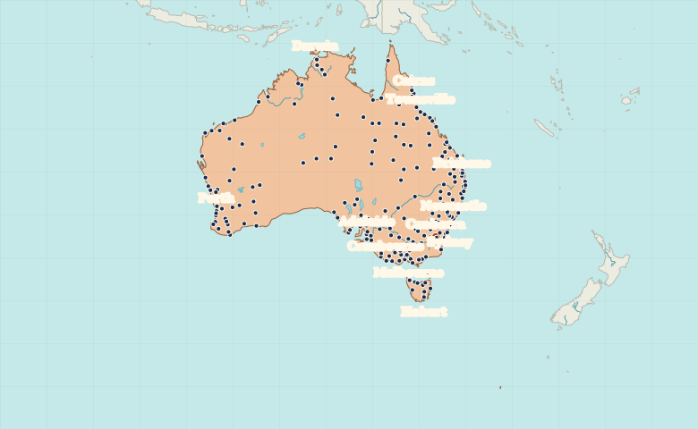
Map of Australia with cities
Compare Sydney, Melbourne and Brisbane with Perth on Australia’s west coast. Find Canberra inland, Darwin in the north and Hobart on Tasmania. City index (224) · Map questions
Reading the map
Coastal capitals and the inland distances
Find Canberra inland between Sydney and Melbourne. Brisbane is farther north on the east coast, while Adelaide and Perth help show the distance across the south. Darwin anchors the tropical north, and Hobart sits across Bass Strait on Tasmania.
| City | Direction | Straight-line distance |
|---|---|---|
| Sydney | Northeast | 247 km / 154 mi |
| Melbourne | Southwest | 466 km / 290 mi |
| Brisbane | Northeast | 946 km / 588 mi |
| Perth | West | 3,090 km / 1,920 mi |
Australia map questions
How do I tell the two places named Richmond apart?
Select Richmond, New South Wales for the place near Sydney, or Richmond, Queensland for the inland Queensland town. The map index includes the state in both names.
How far apart are Sydney and Melbourne?
Melbourne is about 713 km (443 mi) southwest of Sydney in a straight line between their map markers. Road distances depend on the route.
Cities on this map (224)
- Adelaide
- Adelaide River
- Albany
- Albury
- Alice Springs
- Andamooka
- Ararat
- Armidale
- Atherton
- Ayr
- Bairnsdale
- Ballarat
- Ballina
- Barcaldine
- Batemans Bay
- Bathurst
- Bedourie
- Bendigo
- Berri
- Bicheno
- Biloela
- Birdsville
- Bongaree
- Bordertown
- Boulia
- Bourke
- Bowen
- Brisbane
- Broken Hill
- Broome
- Bunbury
- Bundaberg
- Burketown
- Burnie
- Busselton
- Byron Bay
- Caboolture
- Cairns
- Caloundra
- Camooweal
- Canberra
- Carnarvon
- Ceduna
- Central Coast
- Charleville
- Charters Towers
- Clare
- Cloncurry
- Cobram
- Coffs Harbour
- Colac
- Cooma
- Cowell
- Cowra
- Cranbourne
- Dalby
- Darwin
- Deniliquin
- Derby
- Devonport
- Dubbo
- Echuca
- Eidsvold
- Emerald
- Erldunda
- Esperance
- Exmouth
- Forbes
- Forster-Tuncurry
- Gawler
- Geelong
- Georgetown
- Geraldton
- Gingin
- Gladstone
- Gold Coast
- Goondiwindi
- Goulburn
- Grafton
- Griffith
- Gunnedah
- Gympie
- Halls Creek
- Hamilton
- Hervey Bay
- Hobart
- Horsham
- Hughenden
- Ingham
- Innisfail
- Inverell
- Ivanhoe
- Kalbarri
- Kalgoorlie
- Kaltukatjara
- Karratha
- Karumba
- Katanning
- Katherine
- Katoomba
- Kempsey
- Kiama
- Kimba
- Kingaroy
- Kingoonya
- Kingston
- Kingston South East
- Kununurra
- Kwinana
- Launceston
- Laverton
- Leeton
- Leonara
- Lismore
- Lithgow
- Longreach
- Mackay
- Maitland
- Mandurah
- Manjimup
- Maryborough, Queensland
- Maryborough, Victoria
- McMinns Lagoon
- Meekatharra
- Melbourne
- Melton
- Meningie
- Merimbula
- Merredin
- Mildura
- Moranbah
- Morawa
- Moree
- Mount Barker
- Mount Gambier
- Mount Isa
- Mount Magnet
- Mudgee
- Murray Bridge
- Muswellbrook
- Narrabri
- Narrogin
- Newcastle
- Newcastle Waters
- Newman
- Norseman
- Northam
- Nowra
- Oatlands
- Onslow
- Orange
- Ouyen
- Pannawonica
- Parkes
- Penola
- Perth
- Peterborough
- Pine Creek
- Port Augusta
- Port Denison
- Port Douglas
- Port Hedland
- Port Lincoln
- Port Macquarie
- Port Pirie
- Portland
- Proserpine
- Queanbeyan
- Queenstown
- Quilpie
- Ravensthorpe
- Richmond, New South Wales
- Richmond, Queensland
- Rockhampton
- Roebourne
- Roma
- Sale
- Scone
- Scottsdale
- Seymour
- Shepparton
- Singleton
- Smithton
- Southern Cross
- Stawell
- Streaky Bay
- Sunbury
- Sunshine Coast
- Swan Hill
- Sydney
- Tamworth
- Taree
- Tennant Creek
- Thargomindah
- Theodore
- Three Springs
- Tom Price
- Toowoomba
- Townsville
- Traralgon
- Tumby Bay
- Tumut
- Tweed Heads
- Ulladulla
- Victor Harbor
- Wagga Wagga
- Wagin
- Wallaroo
- Wangaratta
- Warrnambool
- Warwick
- Weipa
- Whyalla
- Wilcannia
- Windorah
- Winton
- Wollongong
- Wonthaggi
- Woomera
- Wyndham
- Yamba
- Yeppoon
- Young
- Yulara