Europe / City maps
Map of Ireland with cities
Locate Dublin and Galway on opposite coasts of the Republic of Ireland, then compare Limerick, Cork and Waterford in the south. City index (15) · Map questions
IrelandCity map
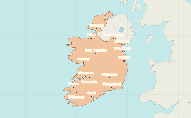
● Capital● City
Reading the map
Dublin, the Atlantic coast and the southern ports
Dublin and Galway sit on opposite coasts. Follow the west side south from Galway to the Shannon estuary near Limerick, then compare Cork and Waterford on the southern side. The highlighted area covers the Republic of Ireland. Northern Ireland is outside its boundary.
| City | Direction | Straight-line distance |
|---|---|---|
| Galway | West | 186 km / 115 mi |
| Cork | Southwest | 220 km / 137 mi |
| Limerick | Southwest | 176 km / 109 mi |
| Waterford | Southwest | 134 km / 83 mi |
Ireland map questions
Does this map include Northern Ireland in the highlighted area?
The highlighted territory is the Republic of Ireland. Dublin, Cork and Galway are within it. Belfast is in Northern Ireland, outside the highlighted area.
How far apart are Galway and Cork?
Cork is about 158 km (98 mi) south of Galway in a straight line between their map markers. Road distances depend on the route.
Cities on this map (15)
- Cork
- Donegal
- Drogheda
- Dublin
- Dundalk
- Galway
- Kilkenny
- Killarney
- Limerick
- Muineachan
- Ros Comain
- Shannon
- Sligo
- Tralee
- Waterford
 Switzerland
 Germany
 Spain
 Italy