Europe / City maps
Map of Spain with cities
Find Madrid inland, Barcelona and Valencia on Spain’s Mediterranean coast, Palma in the Balearic Islands and Las Palmas in the Canaries. City index (49) · Map questions
SpainCity map
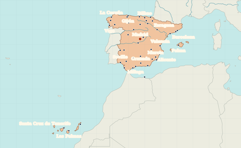
● Capital● City
Reading the map
The central plateau, Mediterranean coast and islands
Find Madrid inland, then follow the Mediterranean side from Barcelona to Valencia and Málaga. Seville lies west of Málaga in the Guadalquivir valley. Zoom out to compare Palma in the Balearic Islands with Las Palmas in the Canaries, southwest of the mainland.
| City | Direction | Straight-line distance |
|---|---|---|
| Barcelona | East | 505 km / 314 mi |
| Valencia | East | 298 km / 185 mi |
| Seville | Southwest | 388 km / 241 mi |
| Bilbao | North | 323 km / 201 mi |
Spain map questions
How do I find Spain’s Balearic Islands and Canary Islands?
Palma marks Mallorca in the Mediterranean, east of mainland Spain. Las Palmas marks Gran Canaria in the Atlantic, southwest of the mainland.
How far apart are Barcelona and Valencia?
Valencia is about 304 km (189 mi) southwest of Barcelona in a straight line between their map markers. Road distances depend on the route.
Cities on this map (49)
- Albacete
- Algeciras
- Alicante
- Almería
- Arrecife
- Badajoz
- Barcelona
- Bilbao
- Burgos
- Cartagena
- Castello
- Ceuta
- Cádiz
- Córdoba
- Gijón
- Granada
- Guadalajara
- Huelva
- Jaén
- La Coruña
- Las Palmas
- León
- Linares
- Logroño
- Lorca
- Madrid
- Marbella
- Mataró
- Melilla
- Murcia
- Málaga
- Mérida
- Ourense
- Oviedo
- Palma
- Pamplona
- Salamanca
- San Sebastián
- Santa Cruz de Tenerife
- Santander
- Santiago de Compostela
- Seville
- Tarragona
- Toledo
- Valencia
- Valladolid
- Vigo
- Vitoria
- Zaragoza
 Switzerland
 Italy
 Ireland
 Germany