Europe / City maps
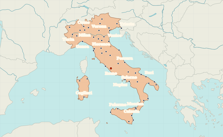
Map of Italy with cities
Trace Italy from Milan and Venice through Rome to Naples. The map also shows Palermo and Catania on Sicily and Cagliari on Sardinia. City index (56) · Map questions
ItalyCity map
● Capital● City
Reading the map
From the Po Valley to the Mediterranean islands
Milan and Turin lie in the north, with Venice near the head of the Adriatic. Follow the peninsula south through Florence, Rome and Naples. The map also includes Sicily, with Palermo and Catania, and Sardinia, with Cagliari.
| City | Direction | Straight-line distance |
|---|---|---|
| Milan | Northwest | 477 km / 296 mi |
| Naples | Southeast | 188 km / 117 mi |
| Palermo | South | 426 km / 265 mi |
| Cagliari | Southwest | 412 km / 256 mi |
Italy map questions
How can I tell Sicily and Sardinia apart on the map?
Find Palermo or Catania on Sicily, the island just off the toe of mainland Italy. Cagliari marks Sardinia, the island farther west and north.
How far apart are Milan and Naples?
Naples is about 657 km (408 mi) southeast of Milan in a straight line between their map markers. Road distances depend on the route.
Cities on this map (56)
- Ancona
- Aosta
- Arezzo
- Asti
- Bari
- Barletta
- Benevento
- Bergamo
- Bologna
- Bolzano
- Brindisi
- Cagliari
- Campobasso
- Caserta
- Catania
- Catanzaro
- Civitavecchia
- Como
- Crotone
- Ferrara
- Florence
- Foggia
- Genoa
- L'Aquila
- Lecce
- Livorno
- Marsala
- Messina
- Milan
- Modena
- Naples
- Novara
- Olbia
- Palermo
- Parma
- Perugia
- Pescara
- Pisa
- Potenza
- Ragusa
- Ravenna
- Reggio di Calabria
- Rome
- Salerno
- Sassari
- Siena
- Siracusa
- Taranto
- Trento
- Treviso
- Trieste
- Turin
- Udine
- Venice
- Verona
- Vibo Valentia
 Switzerland
 Germany
 Spain
 Ireland