United States / City maps
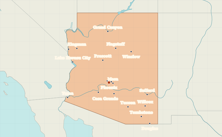
Map of Arizona with cities
Locate Phoenix and its neighboring cities in central Arizona, Flagstaff on the northern plateau, and Tucson and Yuma in the south. City index (19) · Map questions
Reading the map
From the Sonoran Desert to the Colorado Plateau
Find Phoenix in the south-central part of Arizona, with Mesa to its east and Scottsdale to its northeast. From there, the map opens in three directions. Head south to Tucson, northwest to Kingman and north to Flagstaff. Yuma sits in the far southwest on the Colorado River.
| City | Direction | Straight-line distance |
|---|---|---|
| Tucson | Southeast | 176 km / 110 mi |
| Flagstaff | North | 198 km / 123 mi |
| Yuma | West | 253 km / 157 mi |
| Kingman | Northwest | 266 km / 165 mi |
Arizona map questions
Where is Flagstaff in relation to Phoenix and Tucson?
Flagstaff is north of Phoenix, on the Colorado Plateau. Tucson is southeast of Phoenix. Zoom out to see all three cities along the length of Arizona.
How far apart are Tucson and Flagstaff?
Flagstaff is about 340 km (211 mi) north of Tucson in a straight line between their map markers. Road distances depend on the route.
Cities on this map (19)
- Bullhead City
- Casa Grande
- Douglas
- Flagstaff
- Gila Bend
- Glendale
- Grand Canyon
- Kingman
- Lake Havasu City
- Mesa
- Phoenix
- Prescott
- Safford
- Scottsdale
- Tombstone
- Tucson
- Willcox
- Winslow
- Yuma