Cityplate Maps
← Map index

United States

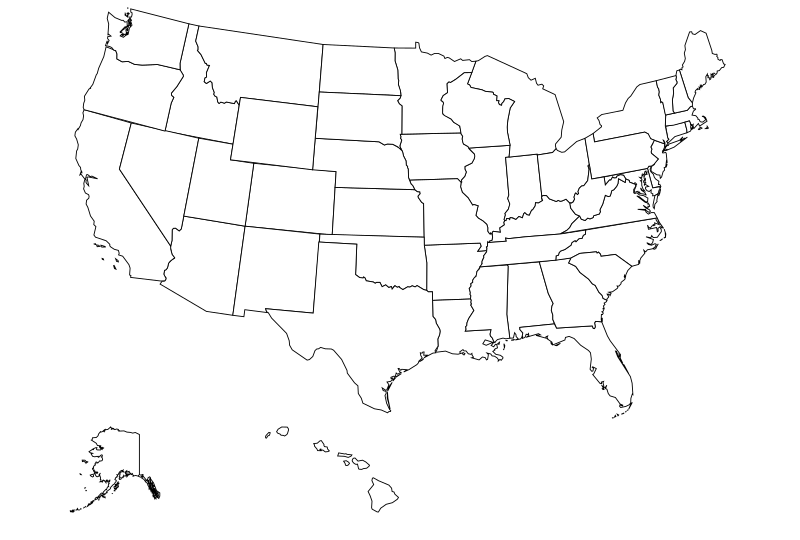
Map of all 50 US states

Select a state on the map or look up its abbreviation and capital.

AlabamaALAlaskaAKArizonaAZArkansasARCaliforniaCAColoradoCOConnecticutDelawareFloridaFLGeorgiaGAHawaiiIdahoIDIllinoisILIndianaINIowaIAKansasKSKentuckyKYLouisianaLAMaineMEMarylandMassachusettsMichiganMIMinnesotaMNMississippiMSMissouriMOMontanaMTNebraskaNENevadaNVNew HampshireNew JerseyNew MexicoNMNew YorkNYNorth CarolinaNCNorth DakotaNDOhioOHOklahomaOKOregonORPennsylvaniaPARhode IslandSouth CarolinaSCSouth DakotaSDTennesseeTNTexasTXUtahUTVermontVirginiaVAWashingtonWAWest VirginiaWVWisconsinWIWyomingWY
Alaska and Hawaii appear below the contiguous states at separate scales. The Hawaii inset shows the main islands. Open full-size US map.

US states, abbreviations and capitals

State mapAbbreviationCapital on the map
AlabamaALMontgomery
AlaskaAKJuneau
ArizonaAZPhoenix
ArkansasARLittle Rock
CaliforniaCASacramento
ColoradoCODenver
ConnecticutCTHartford
DelawareDEDover
FloridaFLTallahassee
GeorgiaGAAtlanta
HawaiiHIHonolulu
IdahoIDBoise
IllinoisILSpringfield
IndianaINIndianapolis
IowaIADes Moines
KansasKSTopeka
KentuckyKYFrankfort
LouisianaLABaton Rouge
MaineMEAugusta
MarylandMDAnnapolis
MassachusettsMABoston
MichiganMILansing
MinnesotaMNSt. Paul
MississippiMSJackson
MissouriMOJefferson City
MontanaMTHelena
NebraskaNELincoln
NevadaNVCarson City
New HampshireNHConcord
New JerseyNJTrenton
New MexicoNMSanta Fe
New YorkNYAlbany
North CarolinaNCRaleigh
North DakotaNDBismarck
OhioOHColumbus
OklahomaOKOklahoma City
OregonORSalem
PennsylvaniaPAHarrisburg
Rhode IslandRIProvidence
South CarolinaSCColumbia
South DakotaSDPierre
TennesseeTNNashville
TexasTXAustin
UtahUTSalt Lake City
VermontVTMontpelier
VirginiaVARichmond
WashingtonWAOlympia
West VirginiaWVCharleston
WisconsinWIMadison
WyomingWYCheyenne

US map questions

Where can I print a blank map of all 50 states?

Open the blank US state outline map and use your browser’s Print command in landscape orientation. State boundaries are visible, with space to write the names or capitals.
Why are Alaska and Hawaii shown below the other states?

They are separate insets, each with its own scale, so all 50 states fit on one sheet. Alaska lies northwest of the contiguous states. Hawaii is in the Pacific, southwest of the mainland. Distances across the inset frames cannot be measured on this overview.

Map sources and methods