United States / City maps
Map of New Jersey with cities
Compare Newark and Jersey City in the northeast with Trenton and Camden on the Delaware. Find Atlantic City and Cape May on the New Jersey shore. City index (13) · Map questions
New JerseyCity map
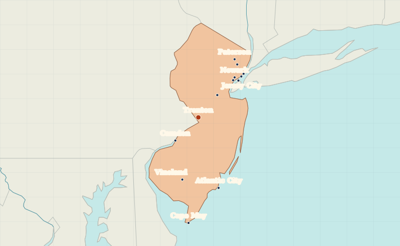
● Capital● City
Reading the map
The Hudson waterfront, the Delaware and the shore
Jersey City and Hoboken face Manhattan across the Hudson. Farther southwest, Trenton and Camden sit on the Delaware River. Trace the Atlantic side from Atlantic City to Cape May, close to the southern tip of the state.
| City | Direction | Straight-line distance |
|---|---|---|
| Newark | Northeast | 72 km / 45 mi |
| Jersey City | Northeast | 79 km / 49 mi |
| Camden | Southwest | 44 km / 27 mi |
| Atlantic City | South | 99 km / 61 mi |
New Jersey map questions
Which New Jersey cities are across the Hudson from Manhattan?
Jersey City and Hoboken are on the west bank of the Hudson opposite Manhattan. Newark lies farther west, away from the Hudson waterfront.
How far apart are Newark and Jersey City?
Jersey City is about 9 km (6 mi) east of Newark in a straight line between their map markers. Road distances depend on the route.
Cities on this map (13)
- Atlantic City
- Bayonne
- Camden
- Cape May
- Elizabeth
- Hoboken
- Jersey City
- New Brunswick
- Newark
- Passaic
- Paterson
- Trenton
- Vineland