United States / City maps
Map of Maryland with cities
Find Annapolis and Baltimore on the western side of Chesapeake Bay, Salisbury on Maryland’s Eastern Shore and Cumberland in the west. City index (12) · Map questions
MarylandCity map
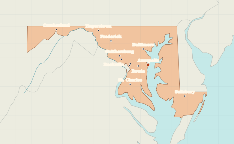
● Capital● City
Reading the map
The Chesapeake Bay and the western mountains
Annapolis sits on the western shore of Chesapeake Bay, south of Baltimore. Find Salisbury on the Eastern Shore, then compare it with Frederick, Hagerstown and Cumberland in the increasingly narrow western part of the state.
| City | Direction | Straight-line distance |
|---|---|---|
| Baltimore | North | 35 km / 22 mi |
| Frederick | Northwest | 94 km / 59 mi |
| Salisbury | Southeast | 103 km / 64 mi |
| Cumberland | West | 209 km / 130 mi |
Maryland map questions
Which side of Chesapeake Bay is Salisbury on?
Salisbury is on Maryland’s Eastern Shore. Annapolis and Baltimore lie on the western side of the bay.
How far apart are Baltimore and Frederick?
Frederick is about 71 km (44 mi) west of Baltimore in a straight line between their map markers. Road distances depend on the route.
Cities on this map (12)
- Annapolis
- Baltimore
- Bowie
- College Park
- Cumberland
- Frederick
- Gaithersburg
- Hagerstown
- Hyattsville
- Rockville
- Salisbury
- St. Charles