United States / City maps
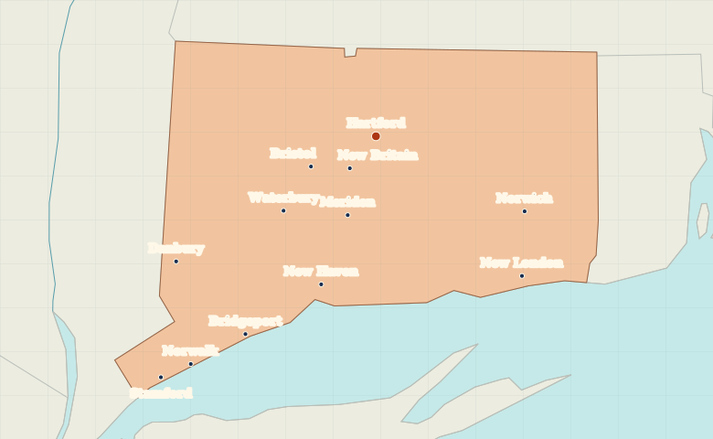
Map of Connecticut with cities
Locate Hartford inland and trace Connecticut’s shoreline from Stamford to New London, with Bridgeport and New Haven along the way. City index (12) · Map questions
ConnecticutCity map
● Capital● City
Reading the map
The Connecticut River and Long Island Sound
Start at Hartford on the Connecticut River, then find New Haven to its southwest on Long Island Sound. Along the coast, Stamford and Bridgeport lie west of New Haven, while New London lies to the east.
| City | Direction | Straight-line distance |
|---|---|---|
| New Haven | South | 52 km / 33 mi |
| Bridgeport | Southwest | 79 km / 49 mi |
| Stamford | Southwest | 107 km / 67 mi |
| New London | Southeast | 67 km / 42 mi |
Connecticut map questions
Which Connecticut cities lie along Long Island Sound?
From west to east, look for Stamford, Bridgeport, New Haven and New London. Hartford is inland, north of the shore.
How far apart are New Haven and Bridgeport?
Bridgeport is about 30 km (19 mi) southwest of New Haven in a straight line between their map markers. Road distances depend on the route.
Cities on this map (12)
- Bridgeport
- Bristol
- Danbury
- Hartford
- Meriden
- New Britain
- New Haven
- New London
- Norwalk
- Norwich
- Stamford
- Waterbury