United States / City maps
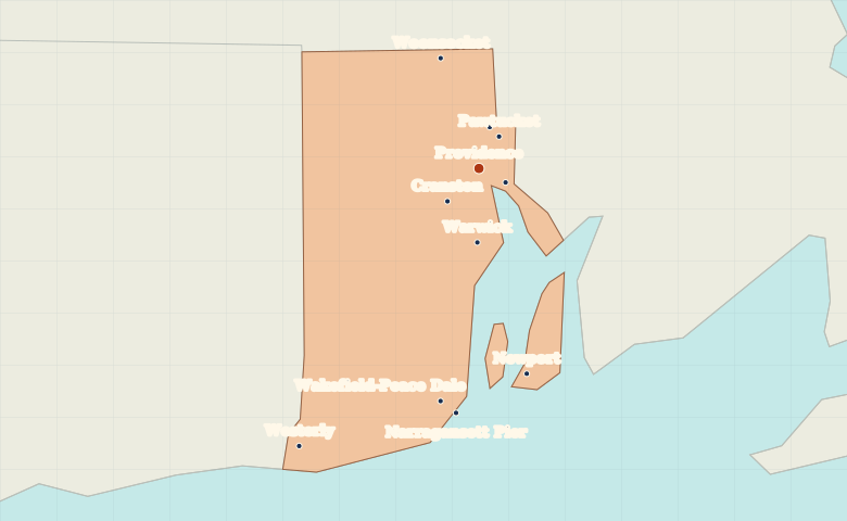
Map of Rhode Island with cities
Locate Providence, Warwick and Newport around Narragansett Bay, then find Woonsocket inland and Westerly near the Connecticut border. City index (11) · Map questions
Rhode IslandCity map
● Capital● City
Reading the map
Narragansett Bay and the southern coast
Providence lies at the head of Narragansett Bay, with Pawtucket to its north. Find Warwick along the western side of the bay and Newport on Aquidneck Island. Westerly marks the southwestern edge by Connecticut.
| City | Direction | Straight-line distance |
|---|---|---|
| Newport | South | 38 km / 24 mi |
| Warwick | South | 13 km / 8 mi |
| Pawtucket | Northeast | 7 km / 4 mi |
| Woonsocket | North | 21 km / 13 mi |
Rhode Island map questions
Is Newport on the mainland of Rhode Island?
Newport is on Aquidneck Island in Narragansett Bay. Providence sits at the head of the bay, and Warwick lies on its western side.
How far apart are Newport and Warwick?
Warwick is about 25 km (16 mi) north of Newport in a straight line between their map markers. Road distances depend on the route.
Cities on this map (11)
- Central Falls
- Cranston
- East Providence
- Narragansett Pier
- Newport
- Pawtucket
- Providence
- Wakefield-Peace Dale
- Warwick
- Westerly
- Woonsocket