United States / City maps
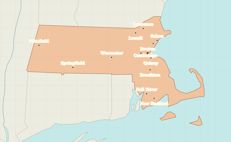
Map of Massachusetts with cities
Find Boston and Cambridge across the Charles River, Worcester in central Massachusetts, and Springfield and Pittsfield farther west. City index (14) · Map questions
Reading the map
From the Berkshires to Massachusetts Bay
Start in Boston and find Cambridge across the Charles River. Worcester marks the middle of the state. Farther west, Springfield lies on the Connecticut River and Pittsfield sits in the Berkshires. On the south coast, compare Fall River with New Bedford to its east.
| City | Direction | Straight-line distance |
|---|---|---|
| Cambridge | Northwest | 6 km / 4 mi |
| Worcester | West | 60 km / 37 mi |
| Springfield | West | 126 km / 79 mi |
| Pittsfield | West | 180 km / 112 mi |
Massachusetts map questions
Where are Boston and Cambridge in relation to the Charles River?
Cambridge lies across the Charles River from central Boston. Select the two city markers in turn to see why they appear almost on top of one another on a statewide map.
How far apart are Cambridge and Worcester?
Worcester is about 57 km (36 mi) west of Cambridge in a straight line between their map markers. Road distances depend on the route.
Cities on this map (14)
- Boston
- Brockton
- Cambridge
- Fall River
- Lawrence
- Lowell
- Lynn
- New Bedford
- Newton
- Pittsfield
- Quincy
- Salem
- Springfield
- Worcester