United States / City maps
Map of Washington State with cities
Explore Washington State from Olympia and Seattle on Puget Sound to Yakima and Spokane inland. Find Vancouver at the Oregon border. City index (16) · Map questions
WashingtonCity map
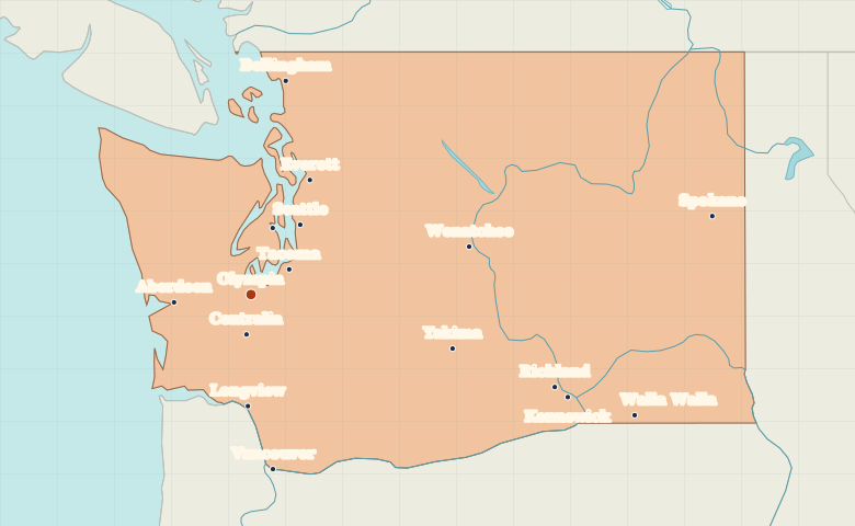
● Capital● City
Reading the map
Puget Sound and the cities east of the Cascades
Olympia sits at the southern end of Puget Sound. Follow the sound north through Tacoma and Seattle toward Everett. Across the Cascades, locate Yakima, the Columbia River cities of Richland and Kennewick, and Spokane near Idaho.
| City | Direction | Straight-line distance |
|---|---|---|
| Seattle | Northeast | 76 km / 47 mi |
| Spokane | East | 419 km / 260 mi |
| Tacoma | Northeast | 41 km / 25 mi |
| Yakima | East | 188 km / 117 mi |
Washington map questions
Is Vancouver on this map in Washington or Canada?
The Vancouver marker here is in Washington State, across the Columbia River from Portland, Oregon. Vancouver in British Columbia is a different city north of the US border.
How far apart are Seattle and Spokane?
Spokane is about 367 km (228 mi) east of Seattle in a straight line between their map markers. Road distances depend on the route.
Cities on this map (16)
- Aberdeen
- Bellingham
- Bremerton
- Centralia
- Everett
- Kennewick
- Longview
- Olympia
- Richland
- Seattle
- Spokane
- Tacoma
- Vancouver
- Walla Walla
- Wenatchee
- Yakima