United States / City maps
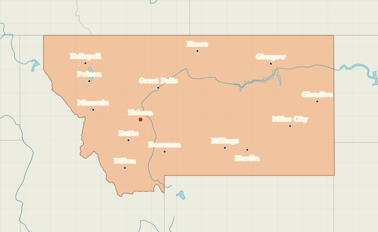
Map of Montana with cities
Compare Helena and Missoula in western Montana with Billings, Miles City and Glendive along the Yellowstone River farther east. City index (14) · Map questions
MontanaCity map
● Capital● City
Reading the map
Western valleys and eastern river towns
Find Helena between Missoula to the west and Great Falls to the northeast. Farther east, Billings, Miles City and Glendive follow the Yellowstone River downstream. Kalispell in the northwest gives a useful reference point for the opposite end of the state.
| City | Direction | Straight-line distance |
|---|---|---|
| Billings | East | 284 km / 176 mi |
| Missoula | West | 152 km / 95 mi |
| Great Falls | Northeast | 115 km / 72 mi |
| Miles City | East | 474 km / 295 mi |
Montana map questions
Which Montana cities help trace the Yellowstone River?
Follow Billings, Miles City and Glendive downstream across eastern Montana. Missoula is on the western side of the state, across the Continental Divide.
How far apart are Billings and Missoula?
Missoula is about 436 km (271 mi) west of Billings in a straight line between their map markers. Road distances depend on the route.
Cities on this map (14)
- Billings
- Bozeman
- Butte
- Dillon
- Glasgow
- Glendive
- Great Falls
- Hardin
- Havre
- Helena
- Kalispell
- Miles City
- Missoula
- Polson