United States / City maps
Map of Oregon with cities
Find Oregon’s Willamette Valley cities, compare Astoria and Coos Bay on the coast, and locate Bend and Ontario east of the Cascades. City index (18) · Map questions
OregonCity map
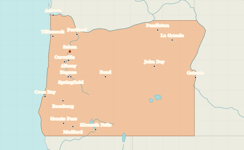
● Capital● City
Reading the map
The Willamette Valley and the Pacific coast
Trace the Willamette Valley south from Portland through Salem to Eugene. Astoria marks the Columbia River near its mouth, while Coos Bay lies farther down the coast. East of the Cascades, Bend and the border city of Ontario show how far Oregon extends inland.
| City | Direction | Straight-line distance |
|---|---|---|
| Portland | North | 71 km / 44 mi |
| Eugene | South | 98 km / 61 mi |
| Bend | Southeast | 167 km / 104 mi |
| Astoria | Northwest | 154 km / 95 mi |
Oregon map questions
Is Bend in the same valley as Portland and Eugene?
Bend lies east of the Cascade Range in central Oregon. Portland, Salem and Eugene run along the Willamette Valley west of the mountains.
How far apart are Portland and Eugene?
Eugene is about 167 km (104 mi) south of Portland in a straight line between their map markers. Road distances depend on the route.
Cities on this map (18)
- Albany
- Astoria
- Bend
- Coos Bay
- Corvallis
- Eugene
- Grants Pass
- John Day
- Klamath Falls
- La Grande
- Medford
- Ontario
- Pendleton
- Portland
- Roseburg
- Salem
- Springfield
- Tillamook