United States / City maps
Map of California with cities
Find California’s coastal cities from Eureka to San Diego, or follow the inland chain from Sacramento through Fresno to Bakersfield. City index (48) · Map questions
CaliforniaCity map
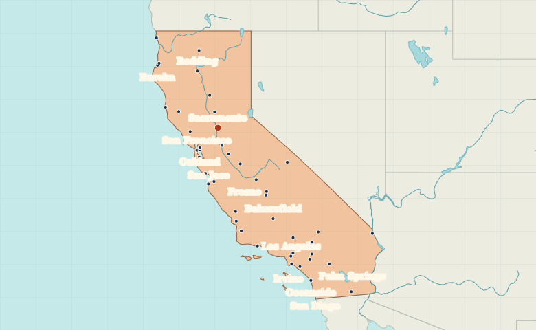
● Capital● City
Reading the map
The Pacific coast and the Central Valley
Trace the Central Valley from Sacramento toward Fresno and Bakersfield. San Francisco and Oakland sit on opposite sides of the bay. Farther south, Los Angeles and San Diego anchor separate coastal metropolitan areas.
| City | Direction | Straight-line distance |
|---|---|---|
| Los Angeles | Southeast | 581 km / 361 mi |
| San Francisco | Southwest | 120 km / 74 mi |
| San Diego | Southeast | 759 km / 472 mi |
| Fresno | Southeast | 252 km / 157 mi |
California map questions
Which cities mark California’s Central Valley?
Follow Sacramento, Stockton, Fresno and Bakersfield from north to south. The coastal cities of San Francisco and Los Angeles lie outside this inland corridor.
How far apart are Los Angeles and San Francisco?
San Francisco is about 560 km (348 mi) northwest of Los Angeles in a straight line between their map markers. Road distances depend on the route.
Cities on this map (48)
- Arcata
- Bakersfield
- Barstow
- Berkeley
- Bishop
- Chico
- Crescent City
- Delano
- El Centro
- Eureka
- Fresno
- Irvine
- Lancaster
- Long Beach
- Los Angeles
- Mendocino
- Merced
- Modesto
- Monterey
- Mt. Shasta
- National City
- Needles
- Oakland
- Oceanside
- Palm Springs
- Pasadena
- Paso Robles
- Redding
- Riverside
- Sacramento
- Salinas
- San Bernardino
- San Diego
- San Francisco
- San Jose
- San Luis Obispo
- San Mateo
- Santa Barbara
- Santa Cruz
- Santa Maria
- Santa Rosa
- Stockton
- Tulare
- Ukiah
- Vallejo
- Victorville
- Visalia
- Yuba City