United States / City maps
Map of Georgia (US State) with cities
Explore the US state of Georgia from Atlanta and Athens to Savannah and Brunswick on the Atlantic coast. Find Macon and Columbus inland. City index (15) · Map questions
GeorgiaCity map
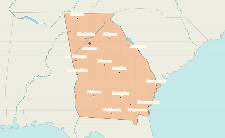
● Capital● City
Reading the map
The Piedmont, coastal plain and Atlantic ports
Find Atlanta in the north-central part of the state. Macon lies southeast of Atlanta, with Columbus farther west on the Alabama line. Along the Atlantic side, compare Savannah near the South Carolina border with Brunswick farther south.
| City | Direction | Straight-line distance |
|---|---|---|
| Savannah | Southeast | 359 km / 223 mi |
| Macon | Southeast | 120 km / 75 mi |
| Columbus | South | 152 km / 95 mi |
| Athens | East | 95 km / 59 mi |
Georgia map questions
Where is Savannah relative to Atlanta and Brunswick?
Savannah is southeast of Atlanta on Georgia’s Atlantic side. Brunswick is farther south along the same coast.
How far apart are Savannah and Macon?
Macon is about 254 km (158 mi) west of Savannah in a straight line between their map markers. Road distances depend on the route.
Cities on this map (15)
- Albany
- Athens
- Atlanta
- Augusta
- Brunswick
- Columbus
- Dalton
- Douglas
- Dublin
- La Grange
- Macon
- Marietta
- Savannah
- Valdosta
- Waycross