United States / City maps
Map of South Carolina with cities
Follow South Carolina from Greenville and Spartanburg through Columbia to the coast. Find Myrtle Beach, Charleston and Beaufort along the shore. City index (12) · Map questions
South CarolinaCity map
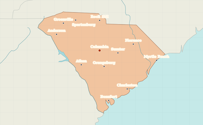
● Capital● City
Reading the map
From the Upstate to the Atlantic shore
Start at Columbia in the interior. Greenville and Spartanburg sit close together in the northwest, and Rock Hill lies near the North Carolina border. Along the coast, Myrtle Beach is northeast of Charleston and Beaufort lies to the southwest.
| City | Direction | Straight-line distance |
|---|---|---|
| Charleston | Southeast | 165 km / 103 mi |
| Greenville | Northwest | 157 km / 98 mi |
| Myrtle Beach | East | 201 km / 125 mi |
| Rock Hill | North | 105 km / 65 mi |
South Carolina map questions
Which is farther south on the coast, Charleston or Myrtle Beach?
Charleston is southwest of Myrtle Beach. Continue southwest from Charleston to reach Beaufort, nearer the Georgia border.
How far apart are Charleston and Greenville?
Greenville is about 319 km (198 mi) northwest of Charleston in a straight line between their map markers. Road distances depend on the route.
Cities on this map (12)
- Aiken
- Anderson
- Beaufort
- Charleston
- Columbia
- Florence
- Greenville
- Myrtle Beach
- Orangeburg
- Rock Hill
- Spartanburg
- Sumter