United States / City maps
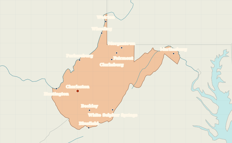
Map of West Virginia with cities
Find Charleston and Huntington in western West Virginia, Wheeling in the northern panhandle and Martinsburg in the eastern panhandle. City index (12) · Map questions
West VirginiaCity map
● Capital● City
Reading the map
The river valleys and two panhandles
Charleston sits on the Kanawha River, east of Huntington on the Ohio. Follow the state’s northern panhandle to Wheeling. In the eastern panhandle, Martinsburg lies much closer to Maryland than to the state capital.
| City | Direction | Straight-line distance |
|---|---|---|
| Huntington | West | 71 km / 44 mi |
| Wheeling | North | 206 km / 128 mi |
| Martinsburg | East | 339 km / 211 mi |
| Morgantown | Northeast | 203 km / 126 mi |
West Virginia map questions
How do I locate West Virginia’s two panhandles?
Wheeling and Weirton mark the narrow northern panhandle between Ohio and Pennsylvania. Martinsburg is in the eastern panhandle near Maryland.
How far apart are Huntington and Wheeling?
Wheeling is about 235 km (146 mi) northeast of Huntington in a straight line between their map markers. Road distances depend on the route.
Cities on this map (12)
- Beckley
- Bluefield
- Charleston
- Clarksburg
- Fairmont
- Huntington
- Martinsburg
- Morgantown
- Parkersburg
- Weirton
- Wheeling
- White Sulphur Springs