United States / City maps
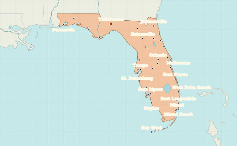
Map of Florida with cities
Follow Florida from Pensacola in the Panhandle to Miami on the Atlantic coast. Find Orlando inland and compare the cities on either side of Tampa Bay. City index (38) · Map questions
FloridaCity map
● Capital● City
Reading the map
Two coasts and the inland peninsula
Start in the Panhandle around Pensacola and Tallahassee, then follow the peninsula south. Tampa and St. Petersburg face each other across Tampa Bay. Orlando lies inland, while Miami and Fort Lauderdale line the Atlantic coast.
| City | Direction | Straight-line distance |
|---|---|---|
| Miami | Southeast | 653 km / 406 mi |
| Tampa | Southeast | 329 km / 205 mi |
| Jacksonville | East | 250 km / 156 mi |
| Orlando | Southeast | 354 km / 220 mi |
Florida map questions
Which side of Florida are Tampa and Miami on?
Tampa is on Tampa Bay on the Gulf side. Miami is on the Atlantic side, farther south. Orlando is inland, so it makes a useful reference point between the two coasts.
How far apart are Miami and Tampa?
Tampa is about 327 km (203 mi) northwest of Miami in a straight line between their map markers. Road distances depend on the route.
Cities on this map (38)
- Apalachicola
- Cape Coral
- Coral Gables
- Coral Springs
- Crestview
- Daytona Beach
- Fort Lauderdale
- Fort Myers
- Fort Pierce
- Gainesville
- Homestead
- Jacksonville
- Key West
- Kissimmee
- Lake City
- Leesburg
- Melbourne
- Miami
- Miami Beach
- Naples
- Ocala
- Orlando
- Palatka
- Palm Coast
- Panama City
- Pensacola
- Port Charlotte
- Sanford
- Sarasota
- Spring Hill
- St. Augustine
- St. Petersburg
- Tallahassee
- Tampa
- Titusville
- Vero Beach
- West Palm Beach
- Winter Haven