United States / City maps
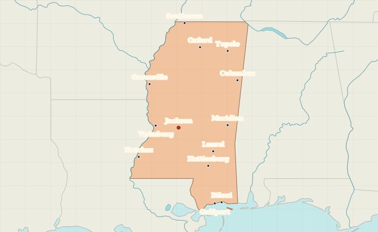
Map of Mississippi with cities
Locate Jackson inland, Natchez and Vicksburg on the Mississippi River, and Gulfport and Biloxi along the Gulf Coast. City index (13) · Map questions
MississippiCity map
● Capital● City
Reading the map
The Delta, the river bluffs and the Gulf Coast
Find Jackson near the middle of the state. Greenville, Vicksburg and Natchez trace the western side along the Mississippi River. Compare those towns with Gulfport and Biloxi on the Gulf Coast and Tupelo in the northeast.
| City | Direction | Straight-line distance |
|---|---|---|
| Gulfport | Southeast | 238 km / 148 mi |
| Biloxi | Southeast | 245 km / 152 mi |
| Tupelo | Northeast | 258 km / 160 mi |
| Natchez | Southwest | 140 km / 87 mi |
Mississippi map questions
Where are Gulfport and Biloxi on the Mississippi coast?
Gulfport is west of Biloxi on the state’s southern shore. The city of Natchez is inland on the Mississippi River, well northwest of both.
How far apart are Gulfport and Biloxi?
Biloxi is about 20 km (13 mi) east of Gulfport in a straight line between their map markers. Road distances depend on the route.
Cities on this map (13)
- Biloxi
- Columbus
- Greenville
- Gulfport
- Hattiesburg
- Jackson
- Laurel
- Meridian
- Natchez
- Oxford
- Southaven
- Tupelo
- Vicksburg