United States / City maps
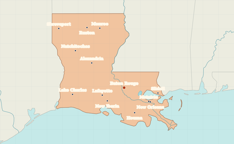
Map of Louisiana with cities
Trace the Mississippi from Baton Rouge toward New Orleans. Compare Louisiana’s southern cities with Shreveport and Monroe in the north. City index (13) · Map questions
LouisianaCity map
● Capital● City
Reading the map
Mississippi River bends and the Gulf lowlands
Find Baton Rouge and follow the Mississippi downstream toward New Orleans. Lafayette and Lake Charles lie to the west across southern Louisiana. The northern cities form a separate group, with Shreveport on the Red River and Monroe farther east.
| City | Direction | Straight-line distance |
|---|---|---|
| New Orleans | Southeast | 115 km / 71 mi |
| Shreveport | Northwest | 337 km / 210 mi |
| Lafayette | West | 89 km / 55 mi |
| Lake Charles | West | 201 km / 125 mi |
Louisiana map questions
Is New Orleans upstream or downstream from Baton Rouge?
New Orleans is downstream from Baton Rouge on the Mississippi River. Lafayette and Lake Charles lie farther west, away from this stretch of the river.
How far apart are New Orleans and Shreveport?
Shreveport is about 449 km (279 mi) northwest of New Orleans in a straight line between their map markers. Road distances depend on the route.
Cities on this map (13)
- Alexandria
- Baton Rouge
- Houma
- Lafayette
- Lake Charles
- Metairie
- Monroe
- Natchitoches
- New Iberia
- New Orleans
- Ruston
- Shreveport
- Slidell