United States / City maps
Map of Texas with cities
Locate Austin between Dallas and San Antonio, then compare the Gulf Coast cities around Houston and Corpus Christi with El Paso in far west Texas. City index (62) · Map questions
TexasCity map
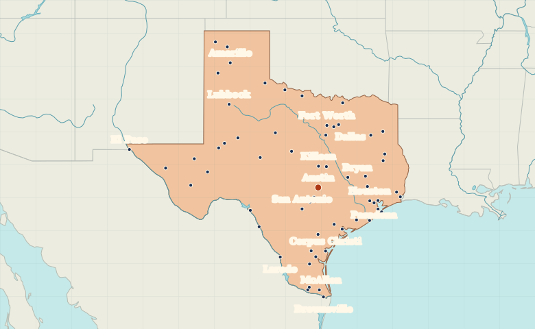
● Capital● City
Reading the map
From the Panhandle to the Gulf Coast
Find the triangle formed by Dallas–Fort Worth, Houston and San Antonio. Austin sits along its western side. Farther west, El Paso marks a separate cluster on the Mexican border.
| City | Direction | Straight-line distance |
|---|---|---|
| Dallas | North | 293 km / 182 mi |
| Houston | East | 238 km / 148 mi |
| San Antonio | Southwest | 119 km / 74 mi |
| El Paso | West | 852 km / 529 mi |
Texas map questions
Which Texas cities form the Texas Triangle?
Start at Dallas in the north, Houston in the southeast and San Antonio in the southwest. Austin falls along the western side, between the Dallas–Fort Worth area and San Antonio.
How far apart are Dallas and Houston?
Houston is about 364 km (226 mi) southeast of Dallas in a straight line between their map markers. Road distances depend on the route.
Cities on this map (62)
- Abilene
- Alice
- Alpine
- Amarillo
- Arlington
- Austin
- Bay City
- Baytown
- Beaumont
- Beeville
- Big Spring
- Brownsville
- Brownwood
- Bryan
- Childress
- Cleburne
- Conroe
- Corpus Christi
- Dalhart
- Dallas
- Del Rio
- Denton
- Dumas
- Eagle Pass
- Edinburg
- El Paso
- Falfurrias
- Fort Stockton
- Fort Worth
- Freeport
- Galveston
- Harlingen
- Hereford
- Houston
- Huntsville
- Killeen
- Kingsville
- Laredo
- Longview
- Lubbock
- Lufkin
- McAllen
- Midland
- Nacogdoches
- New Braunfels
- Odessa
- Pasadena
- Pecos
- Port Arthur
- Port Lavaca
- San Angelo
- San Antonio
- San Marcos
- Sherman
- Temple
- Texas City
- Tyler
- Van Horn
- Vernon
- Victoria
- Waco
- Wichita Falls