United States / City maps
Map of Iowa with cities
Compare Iowa’s Mississippi River cities with Sioux City and Council Bluffs on the Missouri. Find Des Moines and Ames in the interior. City index (14) · Map questions
IowaCity map
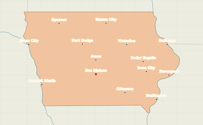
● Capital● City
Reading the map
Cities between the Missouri and the Mississippi
Use the river cities to find Iowa’s edges. Sioux City and Council Bluffs lie on the Missouri River to the west. Dubuque, Davenport and Burlington line the Mississippi to the east. Des Moines and Ames form an inland pair in central Iowa.
| City | Direction | Straight-line distance |
|---|---|---|
| Sioux City | Northwest | 251 km / 156 mi |
| Davenport | East | 252 km / 157 mi |
| Dubuque | Northeast | 265 km / 164 mi |
| Council Bluffs | West | 190 km / 118 mi |
Iowa map questions
Which Iowa cities lie on the Mississippi rather than the Missouri?
Dubuque, Davenport and Burlington are on the Mississippi along Iowa’s eastern edge. Find the Missouri on the opposite side of the state at Sioux City and Council Bluffs.
How far apart are Sioux City and Davenport?
Davenport is about 491 km (305 mi) east of Sioux City in a straight line between their map markers. Road distances depend on the route.
Cities on this map (14)
- Ames
- Burlington
- Cedar Rapids
- Council Bluffs
- Davenport
- Des Moines
- Dubuque
- Fort Dodge
- Iowa City
- Mason City
- Ottumwa
- Sioux City
- Spencer
- Waterloo