United States / City maps
Map of Illinois with cities
Locate Chicago on Lake Michigan, Peoria on the Illinois River and Quincy on the Mississippi. Find Springfield in the state’s interior. City index (22) · Map questions
IllinoisCity map
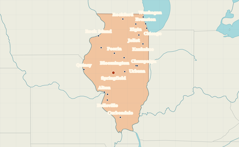
● Capital● City
Reading the map
Lake Michigan and the Mississippi border
Chicago anchors the Lake Michigan shore in the northeast. Find Rockford west of Chicago, then follow the state south to Peoria and Springfield. Rock Island and Quincy lie along the Mississippi on the western boundary.
| City | Direction | Straight-line distance |
|---|---|---|
| Chicago | Northeast | 284 km / 177 mi |
| Rockford | North | 280 km / 174 mi |
| Peoria | North | 100 km / 62 mi |
| Rock Island | North | 204 km / 127 mi |
Illinois map questions
Which Illinois cities on the map are on the Mississippi River?
Rock Island and Quincy mark two stretches of Illinois’s western border. Peoria lies inland on the Illinois River, while Chicago is on Lake Michigan.
How far apart are Chicago and Rockford?
Rockford is about 127 km (79 mi) west of Chicago in a straight line between their map markers. Road distances depend on the route.
Cities on this map (22)
- Alton
- Aurora
- Belleville
- Bloomington
- Carbondale
- Champaign
- Chicago
- Decatur
- Edwardsville
- Elgin
- Evanston
- Galesburg
- Joliet
- Kankakee
- Naperville
- Peoria
- Quincy
- Rock Island
- Rockford
- Springfield
- Urbana
- Waukegan