United States / City maps
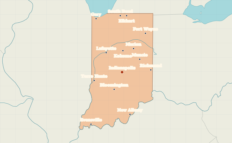
Map of Indiana with cities
Use Indianapolis to find Fort Wayne in northeastern Indiana, Gary on Lake Michigan and Evansville on the Ohio River. City index (14) · Map questions
IndianaCity map
● Capital● City
Reading the map
The lakefront, the capital and the Ohio River
Indianapolis is a useful reference point near the center. Gary lies northwest on Lake Michigan, and Fort Wayne lies northeast. Along the southern edge, compare Evansville in the west with New Albany farther east on the Ohio River.
| City | Direction | Straight-line distance |
|---|---|---|
| Fort Wayne | Northeast | 172 km / 107 mi |
| Evansville | Southwest | 231 km / 144 mi |
| Gary | Northwest | 226 km / 140 mi |
| South Bend | North | 215 km / 133 mi |
Indiana map questions
Which Indiana city is on Lake Michigan?
Gary marks Indiana’s short Lake Michigan shoreline in the northwest. South Bend is farther east and inland, while Indianapolis lies near the center of the state.
How far apart are Fort Wayne and Evansville?
Evansville is about 403 km (250 mi) southwest of Fort Wayne in a straight line between their map markers. Road distances depend on the route.
Cities on this map (14)
- Bloomington
- Elkhart
- Evansville
- Fort Wayne
- Gary
- Indianapolis
- Kokomo
- Lafayette
- Marion
- Muncie
- New Albany
- Richmond
- South Bend
- Terre Haute