United States / City maps
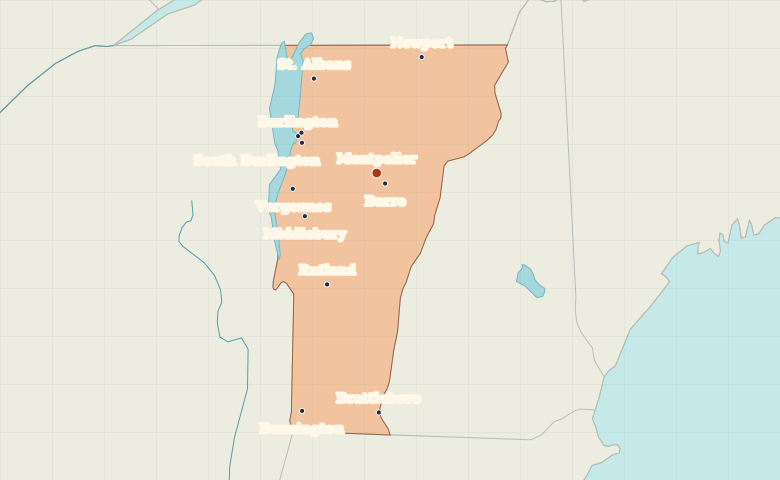
Map of Vermont with cities
Find Montpelier and Barre in central Vermont, Burlington near Lake Champlain, and Brattleboro on the eastern state line. City index (12) · Map questions
VermontCity map
● Capital● City
Reading the map
The Champlain Valley and the Green Mountains
Burlington and nearby Winooski lie west of the Green Mountains near Lake Champlain. Montpelier and Barre form an inland pair. Look south to find Rutland on the western side of the state and Brattleboro on the Connecticut River.
| City | Direction | Straight-line distance |
|---|---|---|
| Burlington | Northwest | 56 km / 35 mi |
| Rutland | Southwest | 79 km / 49 mi |
| Barre | Southeast | 9 km / 5 mi |
| Brattleboro | South | 155 km / 97 mi |
Vermont map questions
Which Vermont city is on Lake Champlain?
Burlington is on Lake Champlain near Vermont’s western edge. Montpelier and Barre lie inland to the southeast.
How far apart are Burlington and Rutland?
Rutland is about 98 km (61 mi) south of Burlington in a straight line between their map markers. Road distances depend on the route.
Cities on this map (12)
- Barre
- Bennington
- Brattleboro
- Burlington
- Middlebury
- Montpelier
- Newport
- Rutland
- South Burlington
- St. Albans
- Vergennes
- Winooski